


002 Le Thoranet

MERMOZ33
User
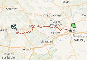

Length
36 km

Max alt
224 m

Uphill gradient
690 m
Km-Effort
44 km

Min alt
38 m

Downhill gradient
548 m
Boucle
No
Creation date :
2018-04-17 17:00:20.016
Updated on :
2018-04-17 17:00:20.016
--
Difficulty : Unknown

FREE GPS app for hiking
 SityTrail
IGN / Geographical institutes
SityTrail Plus
The world is yours!
About
Trail Walking of 36 km to be discovered at Provence-Alpes-Côte d'Azur, Var, Le Muy. This trail is proposed by MERMOZ33.
Positioning
Country:
France
Region :
Provence-Alpes-Côte d'Azur
Department/Province :
Var
Municipality :
Le Muy
Location:
Unknown
Start:(Dec)
Start:(UTM)
303121 ; 4816119 (32T) N.
Comments
pour la premiere fois super